-
Courses
Courses
Choosing a course is one of the most important decisions you'll ever make! View our courses and see what our students and lecturers have to say about the courses you are interested in at the links below.
-
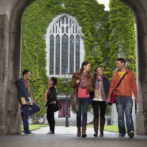
University Life
University Life
Each year more than 4,000 choose University of Galway as their University of choice. Find out what life at University of Galway is all about here.
-
About University of Galway
About University of Galway
Since 1845, University of Galway has been sharing the highest quality teaching and research with Ireland and the world. Find out what makes our University so special – from our distinguished history to the latest news and campus developments.
-
Colleges & Schools
Colleges & Schools
University of Galway has earned international recognition as a research-led university with a commitment to top quality teaching across a range of key areas of expertise.
-
Research & Innovation
Research & Innovation
University of Galway’s vibrant research community take on some of the most pressing challenges of our times.
-
Business & Industry
Guiding Breakthrough Research at University of Galway
We explore and facilitate commercial opportunities for the research community at University of Galway, as well as facilitating industry partnership.
-
Alumni & Friends
Alumni & Friends
There are 128,000 University of Galway alumni worldwide. Stay connected to your alumni community! Join our social networks and update your details online.
-
Community Engagement
Community Engagement
At University of Galway, we believe that the best learning takes place when you apply what you learn in a real world context. That's why many of our courses include work placements or community projects.


News
B.Sc. (Social Sciences) student Natalie Cyrkel’s work on Digital StoryMaps brings Galway’s heritage to life

Jun
04
2024
Posted: 12:17 IST
A crucial element of the B.Sc. (Social Sciences) programme is a semester-long work placement/internship, undertaken by third-year students in their second semester. The programme, in close cooperation with Emma Marron in the Careers Development Office, has worked tirelessly over the past number of years to link with local, regional, and national organisations, institutions, NGOs, businesses and industry to provide essential opportunities for students to develop their employability skills and obtain real-world experience of work within these organisations and companies. One exemplary organisation that the programme has worked closely with over the past few years has been Galway County Council.
This year, B.Sc. (Social Sciences) student Natalie Cyrkel worked with the Heritage and GIS teams of Galway County Council to convert historical data from sources, including O’Donovan’s Ordnance Survey Letters, Griffiths Valuation, the Down Survey, and the 1901 and 1911 censuses, into digital formats. Spearheaded by Galway County Council in conjunction with Galway County Heritage Forum, The Heritage Council and local community and heritage groups, ‘Galway County Heritage Trails’ showcases the cultural and historical significance of almost half of County Galway’s 4,556 townlands through meticulous research and the application of cutting-edge technologies.
Natalie, with fellow University of Galway students Dylan Reilly and Joseph Ennis, worked on one of the standout features of the project, the creation of StoryMaps, a series of interactive maps combining geographical data with multimedia elements to guide users through the historical landscapes of County Galway’s townlands, towns and villages. One hundred sixty-one townlands in the civil parishes of Kiltartan, Kinvaradooras, Kilcolgan, Kilthomas and Killinny were digitised. At the same time, online StoryMaps have also been created for Oranmore, Mountbellew, Monivea and Ballyglunin, bringing to 2,000 the number of townlands now digitised through the project.
At the official launch of StoryMaps at Galway Co Co, attended by Cllr Liam Carroll, Cathaoirleach of the County of Galway, Liam Hanrahan, Director of Services, Director of Services for Economic Development & Planning, Marc Mellotte, Head of Engagement at the University of Galway, members of the Heritage Council and local community and heritage groups, Marie Mannion, Heritage Officer with Galway County Council, stated “in addition to the academic aspect of the project, there is a strong emphasis on community engagement. Galway County Council and the students have worked closely with local heritage and community groups to collect and present local heritage information that enriches the content of the StoryMaps. "This collaborative approach ensures that the digital heritage trails reflect the authentic voices and experiences of the community”.
For some media coverage see Tech Buzz Ireland and Tech Central. To view the StoryMaps and Townland research, visit The Tech Central. To view the StoryMaps and Townland research, visit The Galway Co Co maps page!